
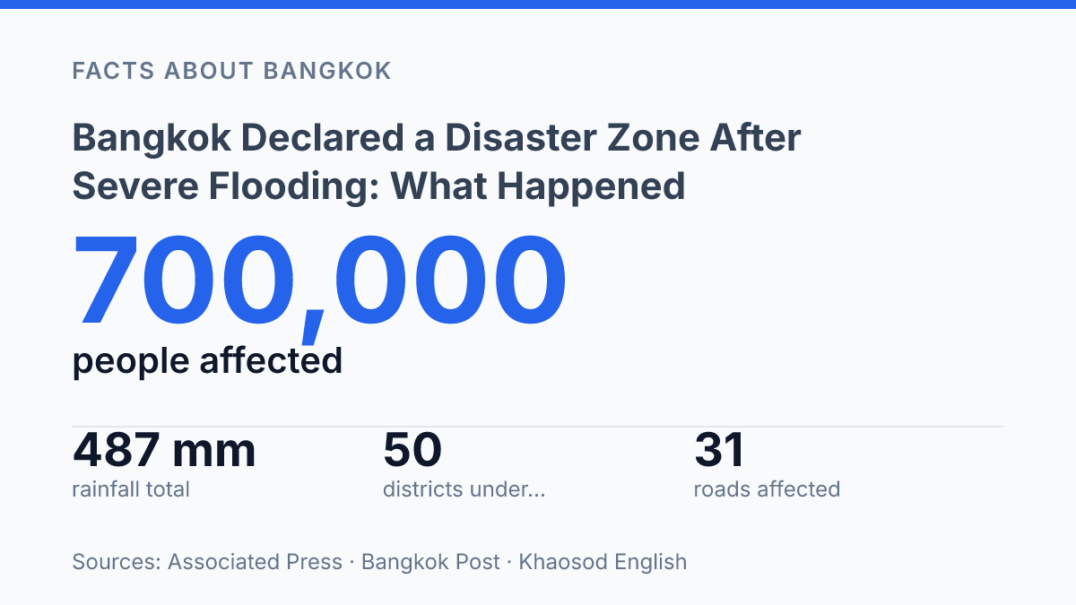
Bangkok declared a disaster zone after severe flooding on September 26, 2026, when emergency powers expanded the affected area from 3 districts to all 50. The decision followed an unusually wet month: the city recorded 487 mm of rain from September 1 to 25, compared with a 1991–2020 average of 269 mm for the same period, about 81% above normal. By then, floodwater was not only pooling in low-lying streets but disrupting roads, rail, bus routes, and airport travel, turning a weather event into a citywide emergency.
The impact was uneven, with central and eastern Bangkok facing some of the heaviest disruption and districts such as Lat Krabang, Min Buri, and Prawet becoming priorities for relief. The declaration also raised a larger question: whether this flood was an exceptional crisis, or a preview of the pressures Bangkok must plan for as extreme rainfall risk grows.
What prompted the disaster declaration
Bangkok’s emergency designation followed a rain anomaly: 487 mm fell from September 1–25, compared with 269 mm in the 1991–2020 average for the same period, according to the Bangkok Post. That made the month-to-date total about 81% above normal before the declaration was widened, creating the conditions for canals, roadside drains, and low-lying streets to overflow in parts of the capital. Associated Press reported that accumulated rainfall in many areas had exceeded 30 cm by September 26, with floodwaters concentrated in central and eastern Bangkok rather than spread evenly across every neighborhood.
On September 26, 2026, the Bangkok Metropolitan Administration expanded the flood-disaster area from three districts to all 50 districts under emergency powers, according to Khaosod English. The move marked a citywide legal classification, not proof that every district had identical water levels or disruption. Such declarations are often applied broadly when rainfall, drainage stress, and flood forecasts create a risk profile that exceeds ordinary administrative handling.
The areas cited in reporting show why the designation was widened despite uneven impacts. Eastern districts including Lat Krabang, Bang Kapi, Sai Mai, Khlong Sam Wa, Min Buri, and Prawet were repeatedly identified among the areas of concern, with Lat Krabang estimated by Bernama to have tens of thousands of flood victims. Central Bangkok also saw flood concentration after the downpours, while transport corridors and road segments remained vulnerable where runoff collected faster than pumps and drains could remove it.
The declaration was therefore prompted by a combination of exceptional rainfall totals and infrastructure overload. Heavy rain alone does not automatically produce a citywide disaster classification, but prolonged accumulation across a dense, low-lying metropolis changes the operational threshold. In this case, the volume of water, its concentration in flood-prone districts, and the spread of risk across administrative boundaries gave authorities the basis to classify the flooding as a disaster-affected event across Bangkok.
Which areas and services were hit hardest
By September 28, the clearest measure of disruption was not a single submerged landmark but the number of people pushed out of normal routines: 700,000 people in about 329,000 households had been affected across Bangkok, according to the Associated Press. Nearly 7,000 people were staying in shelters, which indicates that the flooding had moved beyond short-term street inconvenience into temporary displacement for a smaller but significant share of residents.
Transport was one of the most visible points of strain. As of September 27, the Associated Press reported that 31 roads were still affected by floodwater, while some long-distance train and bus services had been suspended and airport passengers faced delays. Those disruptions matter because Bangkok’s road network carries not only commuters but also food deliveries, emergency vehicles, school travel, and access to medical appointments; even partial road flooding can slow services well beyond the deepest-water zones.
The impacts were uneven across the capital. Media images and citywide emergency measures made the event appear broadly uniform, but the most serious practical disruption was concentrated where drainage was weakest and roads remained passable only with difficulty. Reports available for this period did not confirm named hospitals or major markets as being inundated, but they did show pressure on ordinary local services, including the need for mass food distribution.
One indicator of that pressure was the relief site at Vichutit School in Din Daeng, where a BMA distribution centre could produce about 60,000 cooked meal boxes per meal, or up to 180,000 per day, according to Bernama. The use of a school as a high-volume food hub shows how the emergency affected daily welfare systems, not just transport, and why the declaration translated quickly into shelter, meal, and mobility operations across affected communities.
How officials responded
The response hinged on keeping water moving through Bangkok’s drainage system faster than new rainfall and tidal backflow could slow it down. The Bangkok Metropolitan Administration and district offices treated the emergency as an operations problem as well as a relief problem, deploying sandbags at vulnerable entrances, running pumping stations, clearing drains and canals, and sending crews to remove debris that could reduce flow. These measures were intended to protect homes, roads, public buildings, and access routes for emergency services, but they were not the same as a guarantee that streets would stay dry.
Emergency powers also changed what city officials could do administratively. The disaster designation allowed faster use of emergency procedures for procurement, staffing, and local relief work, while district offices supported temporary evacuation needs for residents who could not safely remain in their homes. Relief distribution focused on cooked food, drinking water, and basic supplies, with city-run logistics backing deliveries to affected communities rather than relying only on individual shelters or ad hoc donations.
National coordination appears to have centered on disaster-management monitoring and warning updates rather than a single military-led operation. The Department of Disaster Prevention and Mitigation was among the agencies responsible for tracking conditions and coordinating support with local authorities, while weather warnings from national forecasters shaped how long pump crews and district teams needed to remain on alert. Available reports did not identify a separate publicly announced citywide emergency-funding total, so the clearest documented response was operational mobilization and relief distribution rather than a named recovery package.
The limits of the response were built into the flood mechanics. Sandbags can slow water entering buildings, pumps can lower standing water, and cleared drains can improve local flow, but all three depend on available drainage capacity and the timing of tides in connected waterways. That makes the immediate response useful for reducing exposure and restoring access, while leaving the underlying flood risk unresolved until water levels, rainfall, and outflow conditions improve together.
What the event signals for future flood risk
Much of Bangkok is only around one to two metres above mean sea level, so even modest increases in water level can reduce the margin between heavy rain and street flooding. Flood-risk researchers, including Aerts and colleagues in studies of Bangkok’s exposure, have linked this vulnerability to the city’s position on the low-lying Chao Phraya delta, soft marine clay beneath the urban area, and land subsidence caused historically by groundwater extraction. Subsidence matters because it raises relative flood risk without requiring a larger storm: the ground lowers while drainage outfalls, canals, and river levels become harder to manage during intense rain or high downstream water levels.
The wider climate signal is not that one episode proves a new trend, but that repeated severe events test systems designed around older rainfall assumptions. In its Climate Risk Country Profile, the World Bank projects that people affected by extreme river flooding in Thailand could rise by more than 2 million by 2035–2044, while coastal flooding could affect a further 2.4 million people by 2070–2100. For Bangkok, that projection is relevant because river discharge from the Chao Phraya basin, local rainfall, tidal influence, and land subsidence can combine rather than act as separate hazards.
Longer-term flood control therefore tends to focus on storage and conveyance, not only emergency pumping. Measures discussed in flood-management planning include larger drainage tunnels, expanded detention ponds and kaem ling retention areas, restored canal capacity, more permeable open space, and coordinated reservoir and river-flow management upstream in the Chao Phraya system. These measures address different parts of the same problem: slowing runoff before it reaches dense districts, moving water through the city faster when capacity allows, and reducing peak river levels when basin-wide rain is the main threat.
The event also points to a planning issue that is harder to solve through infrastructure alone. Continued urban expansion can replace absorbent land with paved surfaces and place more people and assets in low-lying zones, increasing losses even if rainfall risk were unchanged. Future flood resilience will depend on whether drainage upgrades, land-use controls, flood-retention space, and basin management are treated as linked systems rather than separate projects.
What the flood risk now requires from Bangkok
The September 2026 floods make risk planning less theoretical for Bangkok. Emergency meal production, shelters, road closures, and transport suspensions show what response systems can do under pressure, but they also expose the limits of reacting after water has already spread across districts. The longer-term issue is measurable: the World Bank projects that extreme river flooding in Thailand could affect more than 2 million additional people by 2035–2044, with coastal flooding adding further exposure later in the century.
For Bangkok, the practical question is no longer whether major floods can interrupt normal city life. It is how much disruption can be reduced before the next unusually wet month arrives.
Frequently Asked Questions
Q: Why was Bangkok declared a disaster zone after severe flooding?
A: The declaration was made because flooding caused widespread disruption to transport, homes, and public services. Disaster status allows city and national authorities to coordinate emergency response more quickly and direct resources to the hardest-hit areas.
Q: Which areas of Bangkok were most affected by the flooding?
A: The worst impacts typically fall on low-lying districts, canal-side communities, and road corridors that drain slowly during intense rainfall. In a major flood event, these areas can experience longer standing water and more difficult access for residents and emergency crews.
Q: What does a disaster zone declaration mean for residents?
A: A disaster zone declaration usually speeds up access to relief, damage assessment, and interagency support. It can also help authorities prioritise pumping, road clearing, and public safety measures where conditions are most severe.
Q: How does Bangkok usually respond to major flood events?
A: Response efforts generally include water pumping, temporary barriers, traffic management, and warnings for residents in vulnerable areas. Authorities may also monitor drainage systems closely and coordinate with district offices to reduce further damage.
Q: Is flooding in Bangkok a recurring problem?
A: Yes. Bangkok’s low elevation, dense urban development, and dependence on drainage canals make it especially exposed to heavy rainfall and high water levels. That means major flood events can recur when intense rain overwhelms local drainage capacity.